Showing posts with label Western Approaches & Irish Sea (MCZ verification) CEND0312a. Show all posts

Monday, 20 February 2012

Night shift marine life

The night shift have been working since midnight to finish off collecting grab samples and video tow data from the site at South Celtic Deep. When putting down the camera on the grab sampler, we found the ground quite cobbly in places. This meant that we had to use the drop camera to take video and photographs of the seabed in these areas. We saw some great invertebrate marine life living on the seabed, although most of the fish were too quick for us to photograph!

Dahlia anemone at South Celtic Deep

We had a few problems with the camera during the night as it kept turning its flash off and our video and photographs came out dark and blurry. When the problem was fixed by the technical team we managed to get some more good snaps of the interesting marine life living on the cobbles.

Cushion star

We even managed to pick some up in our grab samples for sieving...

We will shortly be steaming down to our next site, Western Channel, where we're sure some more surprises await us. So, goodnight (for us) and we'll be back soon!

Sieving on the edge!

Now that the weather has eased on us and we are getting used to the night shift living patterns, we can tell you a bit more about what we've been up to.

The past two days have been tough with swells up to 4.5 meters and strong winds, but beautiful sunsets.

 Sunset through the porthole (Saturday, 18.02.2012).

At 8am on Saturday, after a few video tows and sediment grabs at East of Celtic Deep (our first site), we were forced to abandon the shift due to the bad weather. 

Hayley (JNCC) and Linford (Cefas) sieving a sediment sample just before we were told to stop by the Bridge.

On Sunday evening the conditions were finally starting to improve. By the end of the shift we had covered all the remaining sampling stations.

Currently we are back to the South of Celtic Deep site, completing the video and sediment grabs that were left to do by the team on the first part of the survey.

Sunday, 19 February 2012

Back to work

We've returned to East of Celtic Deep rMCZ to complete the survey work started during part A of this survey.  Initially we finished off the  multibeam echo-sounder work (see multibeaming East of Celtic Deep ) after a CTD calibration.  The CTD is a small cylindrical probe housed in a robust stainless steel cage that is deployed over the side on a wire and allowed for drop rapidly to close to the seabed.  This takes some judgement as you don't want to let the CTD hit the bottom (hence the steel cage just in case) but you want to take measurements through as much of the water column as possible.  Although you know the depth of water under the boat when you release the CTD you need to compensate for the fact that wind and tide can effect the ship and the CTD differently so the wire is seldom vertical.

CTD in its protective cage. c.50cm long


Why do we need it?  The CTD measures Conductivity, Temperature and Depth every 0.5s as it descends (the downcast), parameters need to to calculate the speed of sound through the water.  This sound profile information is used to calibrate the multibeam echo sounders so that data taken over a period of time can be integrated into a single 'picture' of the seabed.  Analysis of the sound backscatter can provide a broad scale analysis of the seabed type, which is then ground truthed with grab and camera samples.

Talking of which we're at our next station so I need to get back on duty!

Friday, 17 February 2012

Survey dress code

Today we are leaving Swansea's Kings Dock and heading out to our first site on this second part of the survey. Before setting off, Tony, part of the ships crew, gave us a tour of Endeavour to show us where things were and how to move about safely on the ship. The highlight of our induction was getting to try on the glamorous (but essential!) immersion suits. We couldn't get away with not posting a picture of us all wearing the suits after Jenny set such a good example on the first part of the survey.


It's important to make sure we know what kind of suits are on board and how to get them on quickly and correctly in an emergency. Basically, it's vital to follow the dress code!

Thursday, 16 February 2012

All change!

Endeavour is back in the Kings Dock, Swansea, for a quick pit-stop.  When we arrived at lunchtime there were crates of samples and kit being craned off, while fuel was being taken on from a road tanker (the first of two).

Unloading gear with on-board crane
I'm pleased to say several new cameras have arrived, for both the sledge and the drop camera frame to replace those that failed during the last leg of the survey.  This means swapping between towed camera sledge and the drop camera frame will be much quicker - the sledge is great for softer, sandy sediment areas but doesn't like the rocks; the drop camera frame can be lowered to just over the seabed without making contact which makes it ideal for the rocky/boulder type areas.

Beth, Amy, Anita and Jenny have done sterling work (along with the Cefas staff who make up the rest of the team) and all being well, over the next couple of weeks we will finish off sampling at 'East of Celtic Deep' and 'South of Celtic Deep' before steaming to the large 'Western Channel' site, where 68 sampling stations await us.
Ana and Hayley practice multibeam line length calculations

Wednesday, 15 February 2012

Last day at sea

Today has been our last full day at sea before we head back to Swansea, where we will have a JNCC and Cefas staff changeover before the Endeavour heads back out to sea. We have continued to collect multibeam information for the East of Celtic Deep rMCZ. From this we can make out the presence of large sand waves and marks on the seabed. The marks are from fishing boats that are using a type of gear called a beam trawl.
This image shows trawl marks on the seabed - they are running diagonally in pairs.
This afternoon we were lucky enough to be escorted by common dolphins for part of our journey, who seemed to be enjoying the surf created by our bow and stern waves. In the evening we were treated to another spectacular sunset.

Sunset from the bow of Endeavour
We wish the next group of JNCC staff - Ulric, Hayley and Ana  - the best of luck on the next leg of the survey, and goodbye from Amy, Anita, Jenny and Beth!

Multibeaming East of Celtic Deep

Today we continued to multibeam the East of Celtic Deep recommended Marine Conservation Zone, 12 nautical miles south of the Pembrokeshire coast. The map below shows the site and the the area we had multibeamed by approximately 10:30am this morning. The seabed is characterised by subtidal sand (yellow in map), with a patch of mud (brown) in map.


East of Celtic Deep rMCZ with rainbow colouring showing area multibeamed so far
Once the multibeam is processed and analysed the position of the stations for grab samples to be taken will be plotted. The grab sampling will be undertaken in the second part of this survey.  For more information on the East of Celtic Deep site recommendation by the Finding Sanctuary regional project see page 324 of the final report.

Tuesday, 14 February 2012

What will happen to all the data we are collecting?


At the end of this cruise we will have collected a huge amount of samples and data which will need to be processed into a usable form.
  • Benthic ecologists will examine the grab samples using microscopes to identify the different species of marine animals found in the sediment at each survey station. Sediment samples will be examined using particle size analysis, which uses lasers to determine the precise size of particles in the sediment. The information about particle size is used to help define the habitat type.
  • The video and stills from the camera tows will also be analysed to identify the marine life and the physical nature of the seabed at each survey station, in particular the broadscale habitats and features of conservation importance (for a list of MCZ features see here).
  • The multibeam data will be processed using computer software in order to present the bathymetric data in a useful format.
It is important that all of the processed data are labelled with accurate metadata which gives details such as date of the survey and methods used. The format of the metadata is specified by MEDIN (see website).

The processed data will be used to create maps of each survey area which will include information on bathymetry, sediment types, and distribution of biological habitat types.


Our Valentine's gift...

The night shift started with the transit to East of Celtic Deep where we arrived around 6am. At this site the plan is to get full multibeam coverage of the seabed before beginning to pick up grab samples, and so after deploying the CTD we then started the multibeam lines at around 7am. There isn't as much for us all to do when the multibeam is running and so the morning had passed fairly slowly for the first couple of hours until Graham on deck alerted us to dolphins that had appeared on the starboard side of the ship. We all rushed down and over the next 10 minutes they just kept on appearing from all directions  until we were surrounded by about 200 common dolphins all surfing the waves.

Some of the 200 or so common dolphins that were surfing the waves around the vessel

Caught mid-flight


Video of dophins courtesy of Cefas
have a look at the CEFAS blog

A gannet following the action from above

Unfortunately the occurrence of all the dolphins started interfering with the multibeam as you can see from the interruptions on the multibeam image below and so we are now going to have to re-run the multibeam line.

Interference on the multibeam image from the dolphins

Monday, 13 February 2012

The mystery of the missing starfish

Sadly the curse of 12 + 1 continued into the day shift with another kit failure. This time it was the back-up camera which means we are now a little limited with the equipment we can use.  However, despite the set back we have continued to make good progress around our grab sample stations in the South of Celtic Deep rMCZ.

We have also managed to solve the mystery of the missing starfish. This all began when we noticed 'starfish-shaped' imprints in the muddy sand on the seabed, but there were no starfish to be seen anywhere and no trails leading away from the imprints. We later realised that turbulence from the camera sledge being pulled along the seabed was sometimes lifting the starfish up and washing them away. The image below shows a starfish imprint, and the starfish itself.
Starfish imprint at the bottom of the image in the centre

Twelve plus one

We decided to set ourselves a Monday challenge - a start of a new week, so something to add interest to the night shift. The aim was to beat the record of the most stations, by midday when our shift ended. By breakfast at 7.30 with 100% record of first time grabs we'd completed 10 grabs and 3 videos. We resumed after breakfast with our self-imposed target of 15 requiring 5 more stations. Then came along our 13th station, or as George on the bridge would describe it "12 + 1". Earlier in the shift he was told our next station was C13, which he confirmed as "C12+1" and then on asking him what the date was today he informed us it was the 12+1th of  February. Maybe we should have learnt from him as we had the most unsuccessful attempts at this station, but fortunately we still managed to grab at our fifteenth station just before midday.

Map showing 15 stations from C20-C9 (including C12+1)


Sunday, 12 February 2012

Fish identification

The day shift continued with grab samples and video tows at South of Celtic Deep rMCZ. The seabed that we were surveying consisted of muddy sand with some pebbles. We recorded several different species of fish today with the camera sledge. There is a slight delay on the camera shutter so it always tricky to get the timing right otherwise you just get a photo of a disappearing tail!

Common dragonet
Bib
Lesser spotted dogfish (disappearing!)


Another shift, another site

We finished off the last two stations at East of Haig Fras at the start of the night shift and then steamed north for two hours on our way to the fourth site of the survey - South of Celtic Deep.

South of Celtic Deep rMCZ recommended by Finding Sanctuary
This site has been recommended for subtidal sand, subtidal coarse sediment and subtidal mixed sediment although we have been encountering rather a lot of cobbles at our first couple of stations. We had a John Dory come and welcome us to the site when we put the camera sledge down for the first time and he swam along with us as the camera moved across the seafloor for a couple of minutes before moving on.

John Dory (Zeus faber) at South of Celtic Deep rMCZ

Life from the sea floor...

Despite temporarily being down one camera we have been able to capture a variety of life from the seabed today using the camera sledge. The camera sledge is towed along the seabed behind the boat, and is designed for the sandy habitats we have been looking at in the East of Haig Fras rMCZ. As such, it has been a little nerve-wracking today when we have come across patches of boulders and cobbles amidst the sandy habitats as these have been known to damage the camera sledge in the past! However, the camera sledge performed beautifully, and we were able to get some great photos of life from 100m down.

Hermit crab
Devonshire cup corals
Megrim
Octopus
Squat lobster


Saturday, 11 February 2012

Engine room tour


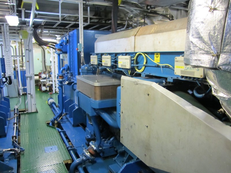
We are still discovering the different sections of the Endeavour, and this morning we found out where the engineers spend most of their day. They offered to take us on a tour to find out what keeps the Endeavour steaming onwards. We were shown the rooms which house the engines, the generators and the motors. The engines drive three generators which generate the electricity to power the two motors which drive the propeller. The generators also provide other electricity which is needed on the ship.


This equipment purifies the fuel for the engines

This is one of the three engines

Motor (drive shaft for propeller is at the bottom)

Glass half full

During the night the Hamcam (the camera attached to the Hamon grab) unfortunately failed so no images could be recorded as the grab hits the seabed and takes a sample. However, by changing the block used to winch the hamon grab we were still able to tell when we hit the bottom and so grabbing continued, as did the camera tows  on the sledge.

In a sandy sediment grab sample we found this biroworm (Hyalinoecia tubicola), which builds a glass-like tube for protection and to live in.

Glass more than half full - biroworm Hyalinoecia tubicola


Fire drill!

This afternoon we had a fire drill on board the Endeavour, where one of the scientists got the chance to play the leading role of 'casualty'. The scenario was an electrical fire in the wet lab, which resulted in an unconscious casualty. In the drill everyone on board the Endeavour played a part, whether it was setting up the fire hose, grabbing the fire extinguishers or acting as a first aider. Drills are really important to make sure we all know what to do in the event of something going wrong for real.
One of the crew getting to grips with the fire hose!

Another crew member in a fire suit with breathing apparatus
The casualty gets carried up to the medical room 

Friday, 10 February 2012

More marine life


As we continue to survey East of Haig Fras rMCZ we’ve seen more interesting marine life in the grab samples and on the camera tows. Although the areas of mobile sandy sediments in this site typically support a lower density of marine life than more rocky areas, we have observed some interesting animals on the seabed including a seven armed starfish. There have also been lots of herring gulls following the boat, probably because they think they might be able to get some fish (no such luck!) 

Seven armed starfish

Juvenile herring gull

What do we do when a Hamon Grab comes up?

Over the past few days whilst we've been at sea we've spoken quite a bit about different types of marine life which have come up in the grab samples and showed some pictures of the equipment in operation but not actually explained what we do with the sample when it comes in so here's a guide to the Hamon grab sampling that we're doing.

The first thing to do is to take a small amount of the sediment and seawater and put it in a plastic box to be send for Particle Size Analysis
The boxes are then stored in the freezer until they can be sent off for analysis
 
We then measure the volume of the total sample before we start sieving...
...and record all of the important information on a whiteboard in the wet lab
First up the sample is sieved through a 5mm sieve which filters out all of the large pebbles, shells and animals such as crabs and brittlestars
All of the material that comes through the 5mm sieve is then sieved through a 1mm sieve and anything smaller than 1mm is discarded
Everything that has stayed behind in the 5mm and 1mm sieves is then put together in a tub and labelled up with the information on the site that the sample was taken from

The samples are then left ready to have the formaldehyde added to them. Once back on dry land all of the samples will then be sent off for analysis to come up with a comprehensive list of all the species that are present.

Thursday, 9 February 2012

Journey to East of Haig Fras rMCZ

We arrived on station at East of Haig Fras recommended MCZ at 10:00pm this evening after a long steam south. During our journey we were temporarily joined by a pod of 9 common dolphins, who looked like they were having fun riding the Endeavour's bow wave.
Common dolphins
The East of Haig Fras rMCZ has been recommended by Finding Sanctuary, who worked with stakeholders to identify and recommend MCZs in the seas around the south-west of England. More information on this rMCZ can be found in the Finding Sanctuary Final Recommendations Report.
The colours on this map represent different types of marine habitat