Wednesday 16 January 2013

Grand finale


We went out with a bang on the final day of the survey, encountering a plethora of sea pens. What should the collective noun for sea pens be? …Set? …Forest? ...Bed?

As we have been very lucky with the weather, we made quick progress and had time left at the end of the main survey programme to do some extra investigations in areas of particular interest. We returned to the core area of Central Fladen site to record some additional video footage around the stations where the tall sea pen Funiculina quadrangularis had been found, in order to better estimate its distribution. The night shift struck gold at one station where a high density of tall sea pens was recorded, and they took some fantastic pictures. Tall sea pens were also found at a number of other stations either side of the area they had been identified earlier in the survey. It appears that they are distributed in a thin band along the Central Fladen site in association with slightly coarser sediment, following the contours of the bathymetry. Stations placed either side of this thin band did not reveal any further tall sea pens.

Brittlestar entwined around a Funiculina seapen

Spider crab (Lithodes maja)
During the day, we also returned to an area to the north-west of the Central Fladen site where multibeam bathymetry revealed a large trench reaching down to over 300m. There was a strong backscatter return at the bottom of this trench which indicated a coarser sediment. We collected video footage and a grab at two locations along this trench in order to groundtruth the bathymetry data and capture any variation in sediment and associated fauna as depth increased. The drop-camera was used as the camera sledge may have run into difficulties being towed down such a step decline. Scientists gathered round to see what the depths would reveal, including a few bleary-eyed members of the night shift who had stayed up especially. The video footage confirmed predictions regarding sediment, showing muddy sand with shells going down and an increasing proportion of cobbles and boulders. A grab was taken at the foot of the slope using the Hamon grab, as this is more effective than the Day grab at sampling coarser sediments. The grab retained sediment with a high proportion of gravel and fewer infauna species.

So that brought the Fladen grounds survey to a close, and we bid farewell to the Scottish seas and began our steam back to Lowestoft. We’ve had an enjoyable and productive survey all in all, successfully confirming the presence of the tall seapen and verifying the burrowed mud habitat predicted in UKSeaMap through ground truthing. Many thanks to the crew of the Endeavour and the Cefas team for a great trip.


Day shift scientists

Night shift scientists

Bridge crew

Deck crew

Signing off (with a sea pen, obviously)

Monday 14 January 2013

Manic monday

We are now sadly coming to the end of the survey. We had planned on collecting some additional video footage in the core area of the Central Fladen site, where we recorded the tall seapen Funiculina quadrangularis last week. However, we were thwarted by the Scottish weather and are now collecting further multibeam data until the swell calms down.Winds have been gusting up to 53 knots for around 24 hours and the swell is around 4 metres.

Stormy seas
Multibeam echosounders (MBES) generate information about seabed bathymetry and from this we can create a map of the seabed to reveal topographical features such as depressions, mounds and trenches. The multibeam echosounder is mounted directly beneath the Endeavour, and transmits an acoustic pulse downward from a transducer at the seafloor. The signal then reflects off the seabed and the return is received by the echosounder. From the two-way travel time, the depth of the seafloor can be estimated. This data is then stitched together by the on-board hydrographic surveyor and a topographic map of the seabed formed.
  
At the same time, backscatter data is collected which records the strength of the return from the echosounder and tellsus something about the nature of the seabed. Different groundtypes can be distinguised from different return signals and may be linked to certain habitat types. One of the features we identified using the bathymetry data was the trench shown in the map below:

3D map of a trench created using processed bathymetry data from MBES
The scientists have been assisting the senior surveyer with logging of bathymetry lines in the plotting room. It is possible to view the position of the boat in relation to the grid of proposed lines and watch the multibeam and backscatter data come in:

Screen displaying incoming backscatter data (top left), survey grid and vessel position (top right) and incoming bathymetry data (bottom right)

While logging bathymetry there has been some free time to complete our survey mascot Nigel the Narwool (nice work, Megan! - editor).

Hello!


Saturday 12 January 2013

Is that mud again?


The survey team has been working at full steam over the last couple of days making excellent progress. We have completed the Central Fladen site and Western Fladen site, and are now progressing quickly through the final South East Fladen site. We’ve had very varied weather with the day shift getting lucky with a burst of bright sunshine, as well as winds exceeding 40 knots, and night shift witnessing a brief flurry of snow.

Nice seascape

The South East Fladen site has mud sediments similar to the other sites with perhaps slightly less sand. There have been no tall sea pens found in either the grabs or the video footage, but the slender sea pen, Virgularia mirabilis, can be seen in abundance. At present, Central Fladen site is the only one of the three to contain the tall sea pen. V. mirabilis is locally common on all coasts and is found at depths of 10-400m. It can grow up to 60cm long and is able to withdraw into the sediment when disturbed. 


Photo of seapen in 1mm fraction of grab

Looking at maps of fishing activity over the last five years, it appears that this area of the Fladen grounds has been fished more heavily relative to the other sites, so we expected to see evidence of this on the seabed. On a few of the camera tows there were as expected a few obvious trawl marks in the mud with more marks that appeared to be older and that had started to backfill with mud. It was clear to us how busy this area usually is as, whilst we were sampling, there were several fishing vessels, a number of oil platforms and a drilling boat in the vicinity.


Image of tankers and platform

The fishery in this region generally focuses on catching the Norway lobster (Nephrops norvegicus), although bottom-dwelling fish may be caught also be caught in the net. We captured a number of fish and shrimp on camera, but the Norway lobster remained elusive leaving only burrows as evidence of its presence. Nephrops live in a gallery burrow that can be very large, with tunnels over a metre in length and up to 10cm in diameter. The burrows have a number of entrances and it is possible to estimate the number of animals from the number of burrow entrances sighted on a video tow, though this is problematic as other species also create burrows in this habitat. For example, burrowing crabs such as Goneplex rhomboids, have also been seen during this survey and create burrows similar to Nephrops, though slightly smaller. Marks observed near the entrance to the burrow can also be used to tell if the burrow is still occupied.


Juvenile dab (Limanda limanda) and pelican's foot (Aporrhais serresianus)


Grey gurnard (Eutrigla gurnardus)


Thursday 10 January 2013

Carpe solem

The weather deteriorated yesterday, becoming more typical of this time of year. The wind increased to 40 knots and the increasing swell meant that the camera sledge was moving up and down in the water column as it was deployed. It was not possible to settle the sledge on the bottom whilst getting a clear picture, so we were forced to abandon camera work until the weather improved and focus on sediment sampling.


To give you a picture of what we have been up to, here is a quick run through of what is involved in sediment sampling.

The ship’s captain, or officer in charge of navigating the ship at the time, tells us  when we are at the correct location selected for sampling. We can track the ships course using GPS and view it on a screen so we can see where the ship is in relation to proposed sample locations.

Navigation screen
Three ABs (able-bodied seamen) then assist by winching the Day grab over the side of the vessel to the seabed. It is possible to tell when the grab reaches the bottom, when the winch wire goes slack. The ABs then call through to the survey lab and a scientist takes a fix of the coordinates where the sample was taken so it can be later plotted on maps. Before deployment, the Day grab is set up with the jaws held open by a bar fitted between hooks on the jaws. When the grab hits the seabed pressure is placed on two plates at the base which push up the bar and release the jaws. As the grab is winched back up the grab wires are pulled taut, closing the jaws of the grab so a sample is retained inside.

Grab sampler set for deployment

When the grab is back on deck, the scientists check the depth of the sample which must be at least 8cm to ensure a sufficient proportion of the infaunal community is sampled. Infauna generally live within the top 5cm of the seabed. If the depth is too shallow, or the jaws of the grab have been held open by shells or stones, the grab will be deployed again. If a good sample is retained, scientists take a small core for particle size analysis which gives information on the size of sediment present and a description of the sediment type. For example, sandy mud or gravely sand, is noted using a standard classification system. A photograph of the sample is also taken as a record.

Depth measure and sediment corer

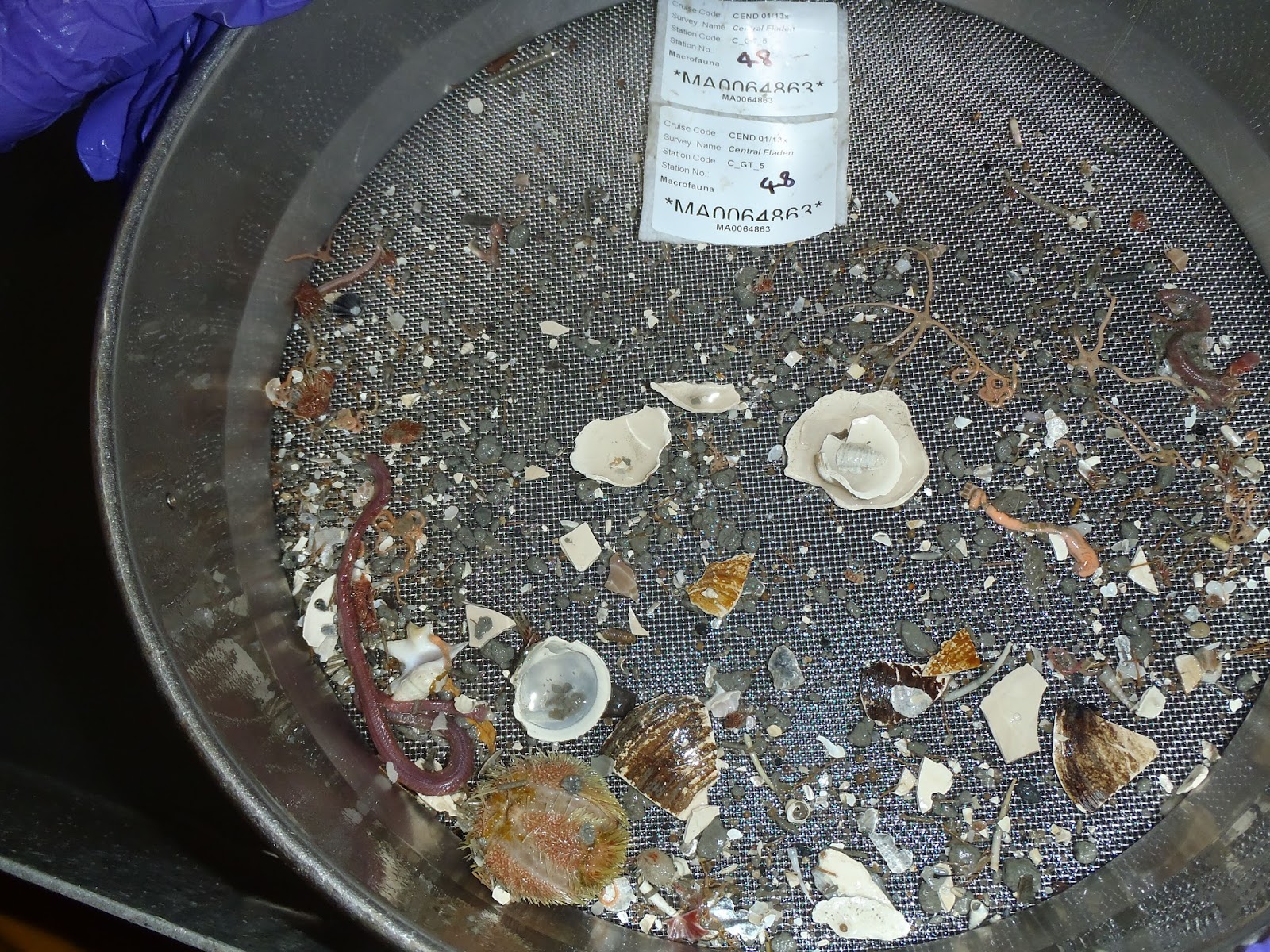
The sample is then dropped into a crate and taken for processing for macrofaunal analysis. The sample is first gently washed through a large 5mm sieve to remove the sediment and large organisms such as sea potatoes, crabs and brittlestars. The sediment and smaller fauna are washed through to a smaller sieve below where fauna larger than 1mm in size are retained. All fauna are then washed into a sample bottle using a funnel and water bottle and then fixed in formalin. Care is taken to ensure no fauna are left behind, and any small organisms caught in the sieve are painstakingly removed using tweezers.

Scientist Dr Paul Whomersley washing sampled fauna from sieve to sample bottle

Some interesting fauna retained in the sieve last shift including several starfish which were tentatively identified as Astropecten irregularis. We even found a mutant individual with only four legs which we took to be good luck.


Retained macrofauna including a sea potato and a starfish, Astropecten irregularis
Grab sample with seapen Pennatula phosphorea

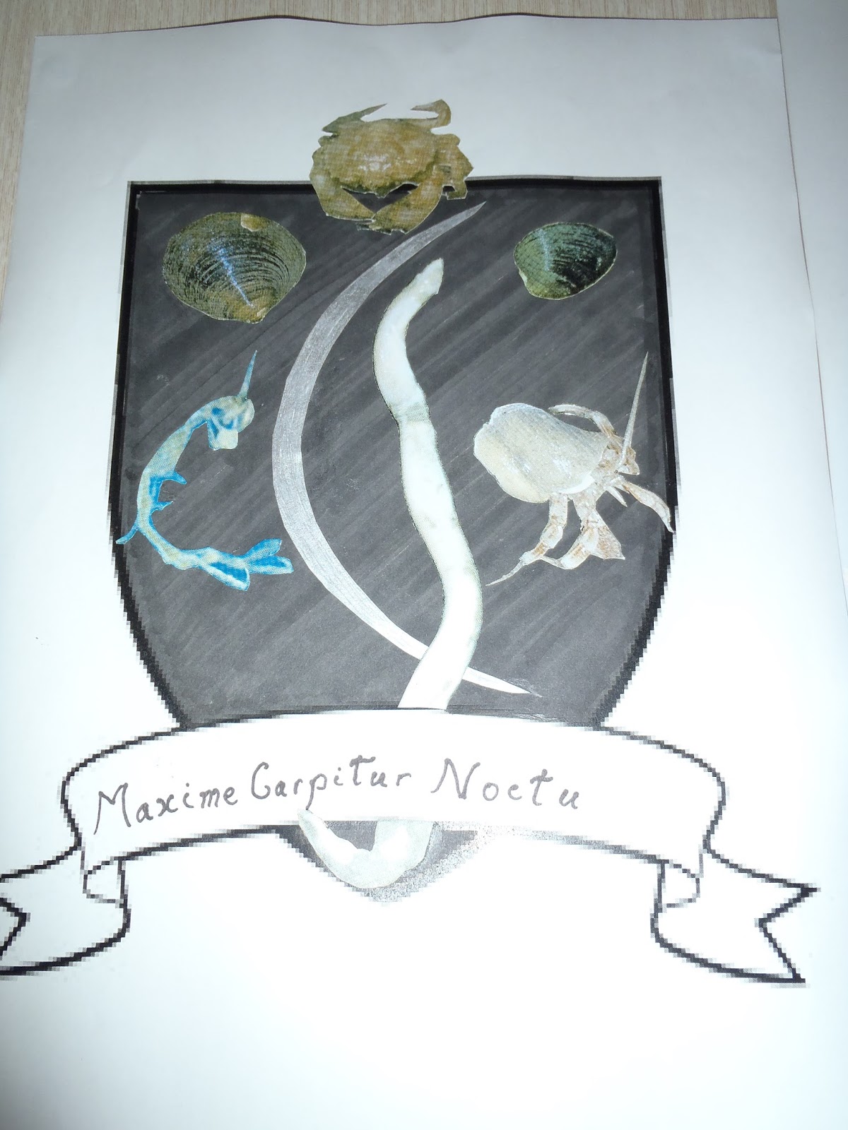
The Scientist in Charge set scientists an imaginative challenge to keep them entertained during down-time. Each shift was charged with creating their own coats of arms and moto. A considerable amount of artistic flair and imagination went into both entries, and the day shift was unanimously victorious with the highly detailed design below (left).

Day shift's coat of arms
Night shift's coat of arms


 The latin motto ‘Carpe Solum’ can be translated (with some artistic license) as ‘grab the earth/bottom’. The seagull and crab are reference to an amusing incident on day shift when we caught a small crab in the grab. Just as we were taking a photograph for records a sharp-eyed gull swept down intent on an easy meal almost taking out an unsuspecting scientist in the process.

Crab found in grab sample
Hungry seagull making a quick getaway

Wednesday 9 January 2013

Snap happy


The video footage from the towed camera sled revealed some interesting creatures over the last couple of days. We had finished surveying the Central Fladen site and moved to a core area in the south east where the tall sea pen, Funiculina quadrangalaris, had been found previously. Everyone waited with baited breath as the camera sledge was lowered around 140m to the seabed in the location where the tall sea pen was spotted in numbers on a survey in 2010. We weren’t disappointed. Tall sea pens, often with a brittlestar clutching the top, were found spread along the video transect. It can be difficult to differentiate between the tall sea pen and the slender sea pen, Virgularia mirabilis, without a physical specimen to examine. The tall sea pen is larger and tends to bend slightly at the top, but juveniles could look very similar to the slender sea pen. 


Above is an image of F. quadrangalaris, with what we suspect is the obligate commensal brittlestar, Asteronyx loveni, wrapped around its body. A. loveni is often found in close association with large Anthozoans such as Funiculina, so we are fairly confident of the identification, but this will be confirmed when back on shore. It has been speculated previously that the brittlestar may gain some advantage from climbing the sea pen, whilst not causing it significant harm. To give you some appreciation of scale, the laser dots on the seabed are 18cm apart.


As on all surveys, there is a goodhearted competition amongst the scientists to take the best underwater photo when in the video hot seat. There were a number of contenders from the day shift, but, for timing, this shot is a clear winner:


Another favourite of mine is this shot of two opisthobranchs, molluscs with an internal shell, appearing to be racing each other through the muddy sediment:


Other organisms we have seen on the survey so far include:

 
A bed of urchins – tentatively Echinus acutus

 
Slender sea pen - Virgularia mirabilis

 
Norway lobster or Dublin Bay prawn – Nephrops norvegicus

 
Well-camouflaged angler or monkfish – Lophius sp.


Deeplet sea anemone - Bolocera tuediae. It is thought that some species such as the shrimp here (possibly Pandalus borealis or Spirontocaris liljeborgii given the association) shelter from predators in the tentacles of the anemone and appear resistant to its stings.

Monday 7 January 2013

Mud, mud, glorious mud


We had a good day’s sampling yesterday. The Scientist in Charge gave both shifts a target number of stations to be completed in a shift to add an element of competition into proceedings. Day shift claimed a very marginal victory completing all their stations, while night shift completed everything but one camera tow.

We started work on the Central Fladen site which was predicted using UKSeaMap to have burrowed mud sediments with an area of slightly coarser sediments to the south east. The tall sea pen, Funiculina quadrangularis, has previously been identified in this region and we hope to confirm its presence here with camera tows. We began with sampling stations to the west of the site, moving from south to north. One grab sample was taken at each station using the Day grab. These samples will be used to determine the sediment type and provide information on the macrofaunal community present in the sediment.


ABs deploy a Day grab

The first grab of the survey taken by night shift sampled sandy mud as expected. Hurray! We also found a hagfish in the sample; a creature not likely to win a beauty contest (although no doubt other hagfish find them attractive). They are well known for releasing an unpleasant slime into the sample. 

Hagfish

Every three stations a camera sledge was deployed to collect video footage and stills of the seabed. This footage will show what fauna is present on the surface, and we expected to find evidence of various burrowing megafauna including seapens and Norway lobsters (Nephrops norvegicus). We were pleased to find that the video also confirmed that burrowed mud was present. We frequently identified the sea pen Pennatula phosphorea, which looks like a red feather, and occasionally the seapen Virgularia mirabilis, as well as seastars and hermit crabs.


Scientists watch the video footage to identify seabed fauna

The grabs all showed similar macrofauna including sea potatoes, brittlestars, amphipods and various polychaete worms.


Macrofauna retained in a typical grab sample

Saturday 5 January 2013

We're off!

We set sail from Lowestoft on the Cefas Endeavour in the early hours yesterday with the crew and a team of Cefas scientists. Luckily the weather is great for January so we've had nice calm seas... so far. It's a long steam to site so we've had plenty of time to prepare for the survey. We made sure all the kit was on board and stowed away safely in case it gets rough.


As this will be the first experience of survey for a few people so the senior scientists gave a quick run through on deck of how the various pieces of equipment work, including the Day grab for soft sediment sampling...

"make sure the jaws of the grab have shut fully when you receive your sample"


... the Hamon grab for stony sediment sampling (which we probably won't need on this trip as we are sampling mud)


...and the sieve table for filtering out all the fauna from the sample.
 
"The top sieve catches large sediment and fauna and the bottom sieve filters out all fauna over 1mm in size."


We sailed onwards up the east coast and had a bit of time to relax and get to know each other. We then found a spot to wet test the gear and made sure everything was in order before the actual survey starts. The camera was lowered to the bottom and we took some practice footage to tweek the settings and make sure we get the best shots possible.


A test grab sample was also taken and senior scientists went over what information needs to be noted and how to process a sample.
 
How many scientists does it take to get a grab sample?
 

Two to collect the sample and the rest to discuss whether it consists of sandy mud or muddy sand!


"I think slightly muddy sand with shells"

We are now in the process of calibrating the multibeam bathymetry gear which is used to record seabed depth. We'll hopefully be ready on site to kick off sampling later this evening.