With the sun shining calm blue seas, and the English coastline on the horizon, our survey of the South West Deep West sites is almost over!
After three successful weeks at sea in which we have completed surveys at two sites, and after seeing many interesting things, we shall be docking in Lowestoft around mid afternoon today.
So, to end our Last blog we have decided to post our last camera tow picture of the survey - which happened to be of a rather big monkfish!
Showing posts with label South-West Deeps (West) & South of the Isles of Scilly (MCZ Verification) CEND0613. Show all posts
Tuesday, 28 May 2013
Saturday, 25 May 2013
Species of the Scilly Isles
After a very busy few days at the South of the Isles of Scilly rMCZ, and with the weather favouring us, we have managed to gather multibeam for the entire site and hamon grab and camera tow samples at over 50 stations!
We have been lucky to see a number of exciting things in South Isles of Scilly site, including an some dogfish, red gurnard and an octopus! And of course, we are still seeing lots of starfish, anemone’s and crabs.
We even had a stow away on the camera sleigh!
As we have made such good time so far, we have decide to return to South West Deeps West rMCZ for our last few days of survey to collection additional multibeam data and maybe even a few some ground truthing samples.
We have been lucky to see a number of exciting things in South Isles of Scilly site, including an some dogfish, red gurnard and an octopus! And of course, we are still seeing lots of starfish, anemone’s and crabs.
| We have hand a number of small crabs in the haman garb macrofauna samples, such as this tiny spider crab. |
We even had a stow away on the camera sleigh!
As we have made such good time so far, we have decide to return to South West Deeps West rMCZ for our last few days of survey to collection additional multibeam data and maybe even a few some ground truthing samples.
Tuesday, 21 May 2013
South of the Isles of Scilly
After ten days on site we have now successfully completed this part of the South West Deep West rMCZ survey collecting information and samples from just over two hundred stations as well as some multibeam data of the relict sandbank features at the site.
After an eight hour steam we have now arrived at our next survey site, South of the Isles of Scilly rMCZ which has been recommended for the broadscale habitats of subtidal coarse sediment and subtidal sand.
Our first two days at the site have been spent collecting multibeam data for the site, after which we shall start some ground truthing using the camera sledge and hamon grab in the hope of finding even more interesting sea life!
After an eight hour steam we have now arrived at our next survey site, South of the Isles of Scilly rMCZ which has been recommended for the broadscale habitats of subtidal coarse sediment and subtidal sand.
Our first two days at the site have been spent collecting multibeam data for the site, after which we shall start some ground truthing using the camera sledge and hamon grab in the hope of finding even more interesting sea life!
Sunday, 19 May 2013
Whats in the Hamon Grab?
Following on from our last blog, a number of hamon grabs have also scooped up a few interesting sea creatures at South West Deeps West including a sea potato, an anemone and worms of all shapes and sizes.
| The sea potato is a heart shaped sea urchin, which likes to bury itself in sand. |
| A sea anemone, picked up by the hamon grab, tentacles withdrawn now that it is out of water. |
![]() |
| A sea anemone underwater, with tentacles extended to catch passing food in the water column |
| A sand mason worm (Lanice conchilega) a species of burrowing worm which builds tubes consisting of sand grains and shell fragments. |
We have also had a look at a number of very small worms found in some of the samples we collected under the microscope. After having a look as what we had been picking out of the sieves for the last week these worms where returned to their samples and will be identified post survey.
Just over half way through our time at sea, we are now nearing the end of our successful survey of South West Deeps West rMCZ.
Friday, 17 May 2013
The Marine life of South West Deeps West rMCZ
After a few shifts of multibeam, the weather has calmed and the beautifully flat sea means that we can continue with ground truthing using the Hamon grab and Camera tow. Whilst unfortunatly we have not had any clear sightings of whales or dolphins, we have had a few avian sightings including a Pomarine Skua. The Skua is a migrant to the UK in both spring and autumn which winters off the coast of West Africa.
Yesterday afternoon the day shift was even lucky enough to see a sun fish! The sunfish is the heaviest known bony fish in the world and produces more eggs that any other vertebrate! Their diet consists of jellyfish- yum yum!
Some interesting species have also been caught on film in the camera tows.
We have had a variety of starfish,
Some sea urchins and anemones,
A number of crabs,
And also even some fish!
Can you spot the Megrim?
Megrim is a species of left eye flat fish which prefer sandy seafloors of between 100m and 700m depth. They eat small fish, as well as squid and crustaceans and can grow up to 60cm. They are caught commercially in some countries.
We have also seen a Cuckoo ray!
Cuckoo rays are easily identified by the yellow and black eye spots on each pectoral fin and can reach up to 75cm in length.
On a few occasions we have also seen schools of Boarfish, a small orange pelagic fish whilst we are dropping the camera tow into position.
We still have at least a few more days of camera and grab work to do at the sites, so we are keeping our fingers crossed for more interesting things!
Tuesday, 14 May 2013
The Hamon Grab
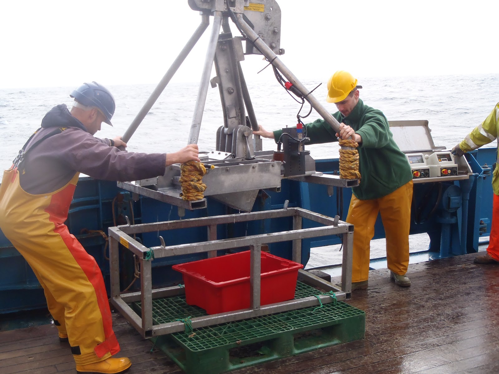
The Hamon Grab (the ‘Ham Cam’) is one of the main bits of survey equipment that we are currently using whilst surveying rMCZ South-West Deeps West. One of the useful things about the Hamon Grab is that three different types of information can be collected- a picture of the seabed before it takes the grab, the sediment present and any animals living in or on the sediment (macrofauna).
The Hamon Grab is deployed over the side of the boat and lowered down to the seafloor where it takes a picture and a sample of the seafloor. It is then lifted back on board.
We then check to see if the grab has collected the sample and take it over to the outside lab. On the rare occasion that a sample is not collected, we give that site three attempts.
The content of the grab sample is then mixed and a sample of the sediment is taken for particle size analysis which occurs post survey.
We then measure the volume of the sample for macro fauna analysis, which will be up to 10 litres, as this is the maximum capacity of the Hamon Grab. A good grab sample will be over 4 litres in volume.
This sample is then passed through a 5mm and 1mm sieve to separate out the macrofauna, which at this site has mainly been worms, and occasionally a bivalve or starfish.
The sieved macrofauna are then panned and we then check that we have not missed any worms which may have got caught in the sieve mesh. The macrofauna sample is then placed into a labelled container for later analysis.
Though we have started to encounter some rough weather again, we are still making good progress with 96 stations completed. However, whilst the bad weather continues, we are now unable to safely deploy the Hamon Grab, so we shall therefore use this as an opportunity to collect some multibeam data.
Saturday, 11 May 2013
South West Deeps West
On Tuesday 7th May we traded places on board the CEFAS Endeavour with April, Eleonora, and Gareth from JNCC who had just completed a 3 week survey. We left Swansea in the evening and headed out for the recommended Marine Conservation Zone (rMCZ) South West Deeps West – approximately 150 miles from shore.
We almost immediately hit some very rough weather, which made the journey uncomfortable for the members of staff on board. We had to make sure that everything was secured to a surface, but even so a beloved puffin mug was broken during a particularly large swell!
Since arriving at the rMCZ on Friday morning, we have been using the Hamon Grab to take samples of the seabed which can be analysed once back on shore. We have also been deploying the camera sledge to video the seabed – and hopefully capture some interesting features on film!
Despite the weather we have been making some good progress and by the end of the third shift have completed 33 stations – only 150 to go!
We are bracing ourselves for some more bad weather over Tuesday and Wednesday and hoping our sea legs have kicked in by then!
On Tuesday 7th May we traded places on board the CEFAS Endeavour with April, Eleonora, and Gareth from JNCC who had just completed a 3 week survey. We left Swansea in the evening and headed out for the recommended Marine Conservation Zone (rMCZ) South West Deeps West – approximately 150 miles from shore.
We almost immediately hit some very rough weather, which made the journey uncomfortable for the members of staff on board. We had to make sure that everything was secured to a surface, but even so a beloved puffin mug was broken during a particularly large swell!
Since arriving at the rMCZ on Friday morning, we have been using the Hamon Grab to take samples of the seabed which can be analysed once back on shore. We have also been deploying the camera sledge to video the seabed – and hopefully capture some interesting features on film!
Despite the weather we have been making some good progress and by the end of the third shift have completed 33 stations – only 150 to go!
We are bracing ourselves for some more bad weather over Tuesday and Wednesday and hoping our sea legs have kicked in by then!
![]() |
| Map showing the South West Deeps West rMCZ in relation to land |
Wednesday, 17 April 2013
Six week survey of Marine Conservation Zones due to start
On Thursday 18th April, six weeks of survey work will start focussing on collecting additional data for recommended Marine Conservation Zones (rMCZs). Time will be split into two back-to-back surveys of three weeks designed to gather more evidence for some of the MCZ recommendations made by stakeholders in 2011.
Within the first survey, three members of JNCC staff will join the Cefas Endeavour research vessel, to undertake detailed survey of three recommended MCZs within the offshore as well as one site within inshore waters. East of Haig Fras is located north west of Lands End and North St George’s Channel and Mid St George’s Channel are located in the Irish Sea (see map below). As there are already some acoustic data available for the sites, the survey work will focus predominately on groundtruthing, using seabed imagery and grab samples as appropriate in order to better characterise the seabed habitat.
All three weeks of the second part of the survey will be dedicated to gathering data for one offshore recommended MCZ. Two members of JNCC staff will join the research vessel at the end of the first survey to head off to the far south-west approaches to survey a site known as South-West Deeps West.
The main aim of these surveys is to gather additional information on the presence and extent of features within sites in order to support the recommendations and aid decision-making on the designation of sites.
Further information on the recommendations made by the regional MCZ projects, along with JNCC and Natural England’s advice can be found on our website.
Within the first survey, three members of JNCC staff will join the Cefas Endeavour research vessel, to undertake detailed survey of three recommended MCZs within the offshore as well as one site within inshore waters. East of Haig Fras is located north west of Lands End and North St George’s Channel and Mid St George’s Channel are located in the Irish Sea (see map below). As there are already some acoustic data available for the sites, the survey work will focus predominately on groundtruthing, using seabed imagery and grab samples as appropriate in order to better characterise the seabed habitat.
All three weeks of the second part of the survey will be dedicated to gathering data for one offshore recommended MCZ. Two members of JNCC staff will join the research vessel at the end of the first survey to head off to the far south-west approaches to survey a site known as South-West Deeps West.
The main aim of these surveys is to gather additional information on the presence and extent of features within sites in order to support the recommendations and aid decision-making on the designation of sites.
Further information on the recommendations made by the regional MCZ projects, along with JNCC and Natural England’s advice can be found on our website.
Subscribe to:
Posts (Atom)