Tuesday 31 October 2017

North East Faroe-Shetland Channel NCMPA: Blog #4

We’re halfway there…

Hello once more from the Scotia, where the first leg of our JNCC and Marine Scotland Science Marine Protected Area monitoring survey has drawn to a close. We have begun making our way from North-east Faroe Shetland Channel NCMPA to Lerwick, Shetland for a day in port to facilitate a staff change before we make for our second survey site (Wyville Thomson Ridge SCI), which is situated to the north-west of Scotland. 


We have collected a lot of very useful information about this site in what has been a great week and a half out here on the north-eastern edge of the UK’s waters.

We have collected data from four survey areas (Boxes A, B, C, and D). The black crosses in the image below show the 37 locations where we completed drop-frame camera stations in Boxes A, B and C. We also completed 15 camera chariot transects in these boxes and collected 8 seabed samples from Box D. 


Thanks to the persistent hard work of the crew and JNCC and Marine Scotland Science scientists aboard, and some good luck with weather, we have achieved our objectives and now have a comprehensive dataset describing the deep-sea sponges and other animals we have observed (some of which have been mentioned and shown in previous blogs), and the seabed habitats which support them. This dataset can now be used to help monitor change within this MPA into the future. 

We will continue to blog throughout the second leg of this survey, so please do stay tuned for new updates and images from the good people on the good ship Scotia!


To find out more information about North-East Faroe Shetland Channel, check out the JNCC Site Information Centre

For more updates from the team, make sure to follow @JNCC_UK on twitter and this blog by entering your email address on the right hand side of the screen.

Written by Joey O’Connor
Images copyright Joey O’Connor/JNCC.

Monday 30 October 2017

North East Faroe-Shetland Channel NCMPA: Blog #3

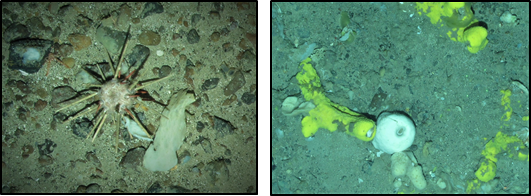
Sid the stonecrab left the house early today to get a head start on his early morning seabed scavenge. At these depths there is no natural light, the water is clear and nearly as cold as that at the poles. The seabed here is not barren, however... far from it. Sid passes through areas thick with a variety of deep sea sponges growing in fantastic forms and sizes as he forages. The area supports a variety of other animals too like cushion stars, brittle stars, pencil urchins, anemones, squat lobsters and fish like ling, torsk and deep sea red fish.


Suddenly, a brightness he has never seen before descends from above, stopping just metres away from him. The brightly lit metallic object pauses for only a moment before moving on, bobbing along its way in the deep. Little does Sid know that hundreds of meters above him, the Marine Research Vessel Scotia is carrying out an extensive survey of the sponge grounds that are his home. In a joint operation, JNCC and Marine Scotland Science (MSS) have been surveying the North-east Faroe-Shetland Channel Nature Conservation Marine Protected Area (NEF NCMPA) for the last week as part of the UK’s MPA monitoring. 


Now that the storm on the surface has abated, the sea is again calm enough to resume survey operations. The joint survey team have been collecting video and photographs of the seabed for the last 36 hours using a dropframe camera system. The sophisticated camera systems are repeatedly lowered off the back of the ‘Scotia’ into the deep in search of their quarry: the deep-sea sponges and their associated animals, including Sid (much to his surprise!). The intrepid crew, a mixture of professional seamen and scientists, will keep up this work twenty-four hours a day until they have collected enough footage to form a picture of this little-known area of seabed. This work will help to better understand and protect Sid’s home among the amazing deep-sea sponges of the Northern North Sea. 


To find out more information about North-East Faroe Shetland Channel, check out the JNCC Site Information Centre

For more updates from the team, make sure to follow @JNCC_UK on twitter and this blog by entering your email address on the right hand side of the screen.

Written by Henk van Rein
Seabed images copyright JNCC/MSS.
Non-seabed images copyright Henk van Rein/JNCC.

Thursday 26 October 2017

North East Faroe-Shetland Channel: Blog #2

We have been busy here at North-east Faroe Shetland Channel since the last blog post. We have all managed to get our sea legs now and have managed to complete all of the chariot video tows. This type of video tow is useful as the equipment can be towed much quicker and for longer than the drop frame camera system (more on that later), allowing us to view a much larger area of seabed. During these tows we have seen a large variety of deep-sea sponges and many different deep-sea fish.


To make the most of the time we have at sea, the team has been split into two, allowing sampling to happen 24 hours a day. Half the team works the “day” shift, midday to midnight, and the other half work “night” shifts midnight to midday. 

We have also been making headway with the grab sampling. This consists of sending the equivalent of a large spade down to the 500m depth and scooping up a small amount of the seabed which we then subsample to investigate sediment particle size. The remainder of the sample is sieved through two different sized sieves to see what marine life and seabed material we have picked up in this area. 


Listening to a variety of musical tunes, going through the decades from 70’s to 80’s, through the shifts has helped the work move along, with the addition of tasty meals and plenty of chocolate and biscuit snacks. We are now moving onto the drop-camera survey. This camera allows us to take high quality still images, which will later be used to identify the different animals seen in the chariot videos.

Sadly, Storm Brian managed to find us yesterday evening, raising the waves to stomach churning levels. Work was suspended as the winds picked up to levels which did not allow us to continue grabbing or video work. This gave the team plenty of time to make sure all the information we had collected was backed up to the various hard drives and computers. It also allowed some time for making sure all of the data is in the correct format, writing blog posts and fixing any computer glitches.

To find out more information about North-East Faroe Shetland Channel, check out the JNCC Site Information Centre

For more updates from the team, make sure to follow @JNCC_UK on twitter and this blog by entering your email address on the right hand side of the screen.

Written by Jessica Taylor

All Images Copyright JNCC. 

Monday 23 October 2017

North East Faroe-Shetland Channel NCMPA: Blog #1

Welcome to the 2017 monitoring survey by Marine Scotland and JNCC onboard RV Scotia to North-East Faroe-Shetland Channel Nature Conservation Marine Protected Area (NCMPA) (Figure 1) and Wyville Thompson Ridge Site of Community Interest (SCI).

Figure 1. North-East Faroe-Shetland Channel NCMPA sampling locations, shown as ‘Box A’ (red points), ‘Box B’ (blue points), ‘Box C’ (purple points) and ‘Box D’ (green points).

The survey is split in to two legs, ten days for the North-East Faroe-Shetland Channel NCMPA and a further ten days on location at Wyville Thompson Ridge SCI. Leaving Aberdeen at 5am on Friday 19th October meant that during the 36-hour transit we had time to prepare all of the equipment, familiarise ourselves with the data management processes and standard operating procedures, and get our body clocks into our various shift patterns allowing us work around the clock (Figure 2).

Figure 2. Familiarisation with (A) the equipment and (B) relevant processes and procedures.
We arrived at North-East Faroe-Shetland Channel NCMPA at midday on Saturday 21st October. The first shift lasted from midday until midnight using Hamon grabs to collect sediment samples from ~660m for particle size and infaunal analysis and working alongside colleagues from Marine Scotland Science who directed the chariot tow video equipment operations (Figure 3B). The video footage from the chariot tow showed coarse-gravelly sediment prevailing, a variety of sponges (potentially including massive, pedunculate, papillate, and flabellate sponges) and multiple sighting of chimera fish. With the first shift over, all chariot tows within ‘Box A’ were complete (Figure 3).

Figure 3. (A) Hamon grab being deployed and (B) Chariot tow set-up.
As the first night shift began the weather took a turn for the worst, with Storm Brian becoming ever closer. This meant that the nights sampling had to be postponed from midnight to 8am on the 22nd October. During this time, the JNCC night shift collated all the metadata from the previous shifts work, backed everything up on multiple hard drives, and ensured all positional information relating to the day’s sampling efforts were stored and correct.

Figure 4. (A) Hamon grab being deployed at night and (B) sea swell preventing further chariot tows and grabs today.
As the first night shift ended, the weather had calmed down considerably, enabling us to begin chariot tow work in ‘Box B’.

To find out more information about North-East Faroe Shetland Channel, check out the JNCC Site Information Centre

For more updates from the team, make sure to follow @JNCC_UK on twitter and this blog by entering your email address on the right hand side of the screen.

By Bekah Cioffi
All images property of Bekah Cioffi.


Monday 16 October 2017

North-East Faroe Shetland Channel NCMPA


North-East Faroe Shetland Channel Nature Conservation Marine Protected Area (NCMPA) is the other site JNCC and Marine Scotland Science are visiting on the upcoming survey.


Designated in 2014, North-East Faroe Shetland Channel is the largest NCMPA in UK waters, stretching from 330m to over 2,000m deep. The focus of this survey are the deep-sea sponges, known to thrive in the nutrient rich 400-600m waters.

Up to 50 different species of Deep-sea sponges live in this channel, providing shelter for a large range of small sea life and a perch for animals that filter food from passing currents.

Probes test temperature and how salty the water is (salinity) to allow the team to paint a better picture of where these deep-sea sponges live. Live video footage and images add to this picture allowing us to identify the sponges. 

The main aim of this survey is to complete Type One monitoring, this is where a robust dataset is collected which can be used to compare this environment now, to how it is in the future.

To find out more information about North-East Faroe Shetland Channel, check out the JNCC Site Information Centre

For more updates from the team, make sure to follow @JNCC_UK on twitter and this blog by entering your email address on the right hand side of the screen.