Tuesday, 30 April 2013

North St George's Channel rMCZ

Day five of surveying at North St George’s Channel is now drawing to a close. Having collected video and still images of the seabed from over 150 stations across this area, we are now gaining a better understanding of the extent and distribution of circalittoral rock habitats within the recommended MCZ site boundary, in particular the extent of drumlins, subtidal biogenic reefs, and horse mussel beds. Over the last week, we have seen a wide range of species, including squat lobsters, edible crabs, red gurnards, small-spotted catshark, bib, crinoids, sunstars and peacock worms.

North St George’s Channel rMCZ is the largest site we will be surveying on this trip (1388km2) and is composed of a variety of habitat types. A map illustrating the diversity of macrofauna present within this site can be viewed below:


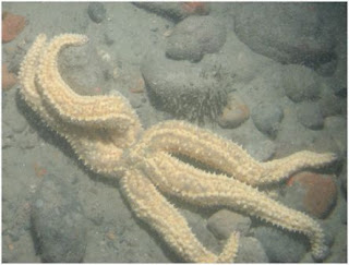
From centre top clockwise: a crust of Sabellaria spinulosa worms; a lone squat lobster (Munida rugosa); a common starfish (Asterias rubens) feeding, surrounded by dead man’s fingers (Alcyonium digitatum); a large common starfish surrounded by brittle stars; Modiolus modiolus shells on muddy sand; two large common urchins (Echinus esculentus) and a common starfish; an edible crab (Cancer pagurus); a crinoid (Antedon bifida) surrounded by hydroids on a patch of MDAC; and a squat lobster with a swimming crab on an outcrop of MDAC.

Features of particular interest indentified during this survey include:

MDAC
Methane-derived authigenic carbonate (MDAC) outcrops were observed at numerous stations across the site. MDAC concretions are formed by microbial oxidation of methane and other gases that bubble up from below the seafloor. The structure itself functions similarly to a reef, providing a surface for attachment and refugia for associated species. However, they can also support unique chemosynthetic organisms that survive on the leaking gases. Submarine structures made by leaking gases, such as MDAC, are listed as Annex 1 habitats under the Habitats Directive and there a number of offshore SACs designated to protect these habitats and associated communities.


A pavement of MDAC projecting above sandy sediment providing a surface for attachment of a hydroid, Flustra foliacea, and dahlia anemone, Urticina felina

Biogenic Reef

Modiolus modiolus
Horse mussel shells (Modiolus modiolus) were found scattered on the surface of the seabed at a number of stations and a live specimen was found in a Hamon grab sample. These organisms live either half-buried in sediment or attached to hard substrate and can clump together to form extensive beds or reefs.

Sabellaria spinulosa
Crusts of Sabellaria spinulosa were also found in a number of locations across the site and their presence was confirmed by use of the Hamon grab. They can occur in large numbers offshore and are able to form extensive reef structures from sand and gravel. Biogenic reefs such as these provide a home to many species such as sponges and corals as well as giving shelter to fish and crustaceans. JNCC hosted a workshop in 2007 in order to better define S. spinulosa reef and published a report to summarise what was agreed.


Suspected Sabellaria spinulosa tubes in a grab sample from North St George’s Channel. The sediment fraction <1mm has already been sieved out.

Drumlins
Drowned drumlins are elongated submarine hills formed within a retreating glacier. There are a few competing theories as to exactly how they are created, but they are composed of glacial till and are typically found in conjunction with other glacially-formed features such as eskers, which are long, winding, ridges formed by streams within and under glaciers. 

Drumlins are listed as geomorphological features of interest in the MCZ Ecological Network Guidance.


Drumlin features visible in a hillshade output from a multibeam echo-sounder in the northeast corner of North St George’s Channel rMCZ

We should finish work on North St George’s Channel tomorrow evening, when we’ll start the 70km transit south to Mid St George’s Channel. This site already has nearly full-coverage multibeam data, so we know a little about the bathymetry and hardness of the seabed, but it requires camera work and sediment samples to be taken in order that we can link acoustic signatures with actual ground types.

Saturday, 27 April 2013

Gulls on film

Hello from the Endeavour!

We are currently at our third survey site: “North St George’s Channel”.  From the plotting room, we have an amazing view out over a sparkling blue sea, and we can see in the distance the Isle of Man, Northern Ireland, Wales (Anglesey), and Scotland.

We are still collecting video footage and still images of the seabed and have visited about half of the planned 150 stations at this site.  The weather has been good for the main part, though we have experienced strong tidal currents, and all is going according to plan.

In between collecting evidence of the seabed habitats, our resident twitchers have been photographing and identifying the many seabirds following the Endeavour. In today’s blog we would like to share some of our favourite pictures of the seabirds in the Irish Sea. All of these images were taken by our on-board photographer, Eleonora, in strong winds when the birds were closest to the boat.

We have seen plenty of gannets. These large birds were not afraid to come very close to the boat.  We’ve seen them plunging in the sea like bullets from a great height to catch fish (sorry, no photo of them doing this as yet).


Northern Gannet (Morus bassanus) in flight

A large flock of fulmars also followed us, possibly to get a break from the strong winds, or maybe hoping to get an easy meal. Fulmars are foragers and have a varied and diverse diet. These birds are relatives of the albatross (albeit much smaller), they look like sea gulls for their grey/white colours, but are easily distinguishable by their distinctive shape and a bump in their beak. The bump is used to expel extra salts ingested with their fishy diet.


Gliding Fulmar (Fulmarus glacialis) enjoying the high winds

We have seen some guillemots, which are the commonest auk in the British Isles, but they were not at all interested in us and we only saw them in the distance. If you squint at the image below you may just be able to make them out.


Guillemots (Uria aalge) in single file

Kittiwakes were also flying at the stern of the Endeavour, seeking shelter. These elegant sea birds are often seen in the open sea, usually feeding on waste from commercial fishing vessels. They fly to the UK to breed and they return to the Atlantic in winter.


Kittiwake (Risso tridactyla) soaring

A slightly more unusual visitor, spotted by the night shift, was a very bedraggled male wheatear, pausing for a break on its long migration back from Africa to breed. He rested on our grab for a short time and we managed to take this picture of him.


Wheatear (Oenanthe oenanthe) taking a well-earned rest

On the same day we also had a small yellow bird visiting the night shift flitting around inside the dry lab. The unidentified bird was a flash of yellow darting across the room, hitting Steve, and flying out again. Seeing these little birds flying away towards a vast dark sea, made us better appreciate the vast scale of their migration and the amazing effort that must be required.

As well as benthic macrofauna and seabirds, we have also observed harbour porpoise and common dolphins. Unfortunately, these encounters were too brief to photograph.

Wednesday, 24 April 2013

SUPER MARIO’S STAR MENAGERIE

Early this morning we finished surveying at East of Haig Fras rMCZ and are now en route to North St George’s Channel. The steam will take around 13 hours, which will enable us to check that all of our newly acquired data has been recorded correctly.

East of Haig Fras rMCZ

Grab samples of the sedimentary habitats and video and still images have already been collected here from a previous survey aboard the Cefas Endeavour and an external contractor has collected full-coverage multibeam over the site. Broadscale habitat maps produced by Cefas scientists, based on these data, modelled small patches of circalittoral rock on the crests of topographical features repeated across the site. This part of the survey is intended to validate the presence of circalittoral rock within the East of Haig Fras site and to collect sidescan data in order to better differentiate coarse sediment and rock habitats.

We employed a drop-camera in this instance, as the camera sled may have snagged on the rocky substrate. Pictured below are some of the species we observed whilst surveying East of Haig Fras seabed habitats:

Marthasterias glacialis (spiny starfish)       

Porania pulvillus (red cushion star)


Caryophyllia smithii (Devonshire cup coral)

Luidia ciliaris (seven-armed starfish)

Munida rugosa (rugose squat lobster)


Aspitrigla cuculus (red gurnard)

Although the data has yet to be processed, preliminary results suggest that the modelled habitat map is a good fit to the broadscale habitats we observed on the camera tows.

It has not yet been a week since we were last on dry land, but already life at sea is beginning to take its toll on some of the JNCC staff.


Gareth Johnson A.K.A. Super Mario

However with a little help from Super Mario, the efficient Cefas Endeavour workforce has now completed the next stage of this MCZ site verification survey.

Number of hours at sea: 144
Number of stations completed: 125
Number of puddings consumed by April: Lost count! Maybe 13?


Tuesday, 23 April 2013

The Med or the English Channel?

Hello again from the Endeavour!

The sun is still shining and The English Channel is incredibly calm! It looks rather like the Mediterranean Sea (albeit on a cold spring day).

The crew is great, all equipment has been working fine, and everything is currently going according to plan.  Most of the crew and scientists are organised into two work shifts: the day shift (from midday to midnight) and the night shift (the 12 remaining awkward hours).

For the past three days, and nights, we have been working in the South Dorset rMCZ, gathering evidence on the extent and distribution of the habitats for which this marine protected area has been recommended. In particular, we are recording video footage and taking photographs of the seabed, as well as collecting samples of the surface sediment and macrofauna. So far, we have visited 85 of the 87 planned sampling stations, so we should be finished by midday on the 22nd April.

We deploy different sampling instruments depending on the type of seabed that we expect to find, and the information needed for that particular location.
We have three different video cameras systems on board, but for the South Dorset site we mainly used the drop camera frame. This system is designed for rocky seabeds, as there is less risk that it will snag on rocky protrusions or other obstructions. It has an underwater video camera which can also take high resolution still images and is equipped with a flash and two strobe video lights.

Deploying the drop camera system at sunrise.

The camera is controlled from the onboard laboratory, where the video can be viewed real-time, via the armoured umbilical cable. At South Dorset, we have seen many Dahlia anemones, carpets of brittlestars, plenty of crabs, and colourful encrusting sponges and sunstars.


Here is Marc, one of the night shift videographers. He is in charge of adjusting the settings of the camera, “pressing the shutter” to take still photographs, and making sure that the video is actually recording the images.

During a video tow, still photographs are taken at 1 minute intervals (see the MESH habitat mapping guidance, http://www.searchmesh.net/default.aspx?page=1562) for statistical purposes. A photograph is recorded also when particular features or species are seen on video to help aid characterisation of the habitat.

A fish!!! Cheered us up after a rather boring camera tow on sand, in the middle of the night. We think this is most likely to be a thornback ray (Raja clavata) (or half of it) (photo by Marc)


Two poor cods posing for the camera (Trisopterus minutus) (photo by Buster)


Here is another shot taken at night, a European lobster (Homarus gammarus)(picture by Marc)

When possible, in areas with soft sediments, we collected sediment samples using the Hamon grab. A highlight was finding some small fossils visible in the photo below.


More news from us soon!

Cake Count
Eleonora = 7  
April = 8
Gareth= 5


Friday, 19 April 2013

A BRIGHT START

We boarded the Cefas Endeavour late on the evening of April 17th. With the ship not scheduled to set sail until the following afternoon, we had plenty of time to explore the ships facilities and settle into our spacious cabins.


CEFAS Endeavour. Our home for the next 3 weeks!


Our luxurious accommodation

On the morning of the 18th, we were introduced to the rest of the team and crew. After an initial safety induction, it was all hands on deck to get the equipment ready for the upcoming surveys.  Despite initial weather worries, we set sail as planned departing Lowestoft harbour around 15:30.  After a long steam down the English Channel, we are predicted to arrive at our first site ‘South Dorset’ rMCZ at 13:00 Friday 19th April.

Day 1 Cake Count:
Eleonora – 4 slices
April – 3 slices
Gareth – 2 slices


Marc (right) and Buster (left) setting up the camera sledge. Marc is our hero (well actually Marc's wife) as he came on board with two delicious cakes!


Anna (left) presenting Alex and Paulette the survey plan for our fist site.


 Lowestoft harbour bridge opens to let us out!


April and Eleonora reporting from the English Channel

Wednesday, 17 April 2013

Six week survey of Marine Conservation Zones due to start

On Thursday 18th April, six weeks of survey work will start focussing on collecting additional data for recommended Marine Conservation Zones (rMCZs). Time will be split into two back-to-back surveys of three weeks designed to gather more evidence for some of the MCZ recommendations made by stakeholders in 2011.

Within the first survey, three members of JNCC staff will join the Cefas Endeavour research vessel, to undertake detailed survey of three recommended MCZs within the offshore as well as one site within inshore waters. East of Haig Fras is located north west of Lands End and North St George’s Channel and Mid St George’s Channel are located in the Irish Sea (see map below).  As there are already some acoustic data available for the sites, the survey work will focus predominately on groundtruthing, using seabed imagery and grab samples as appropriate in order to better characterise the seabed habitat.


All three weeks of the second part of the survey will be dedicated to gathering data for one offshore recommended MCZ. Two members of JNCC staff will join the research vessel at the end of the first survey to head off to the far south-west approaches to survey a site known as South-West Deeps West.

The main aim of these surveys is to gather additional information on the presence and extent of features within sites in order to support the recommendations and aid decision-making on the designation of sites.
 
Further information on the recommendations made by the regional MCZ projects, along with JNCC and Natural England’s advice can be found on our website.

Friday, 5 April 2013

Homeward bound


With work complete at Bassurelle Sandbank, we dug out the passage plan and headed for Lowestoft.  Both day and night shifts were feeling pretty happy with their achievements over the past few weeks.  The friendly rivalry that developed between the two shifts gave that extra incentive to try and squeeze in one more grab or camera transect before the other shift took over.


The 'Night Watch' minus Shift Leader Paul McIlwaine (who's behind the lens) ....can you spot 'Wilson'?

During the steam back, the order of the day was data QA - checking and rechecking metadata and records from the survey so it would ready to be analysed and interpreted once we docked.


Sunset on the last day of survey (Photo: Neil Golding)
 All that's left now is for me to thank Paul Whomersley, Scientist in Charge for the survey for ensuring that the everything ran smoothly and that we met and exceeded our cruise objectives, despite some poor weather at times.  Also, a special 'thank you' to Paul Kersey and the crew of the Cefas Endeavour for keeping us in position and on track during the survey.  A final thanks to Joey and Mike for keeping the blog updated over the past few weeks.  Hopefully you've enjoyed keeping up to date with our progress.