Friday, 18 May 2012


We left Berwickshire and North Numberland SAC and arrived at Swallow Sand rMCZ late on Wednesday night following an 8 hour transit. Like Fulmar rMCZ, it is not possible to map all of Swallow Sand in the time available due to its huge size (~ 4,000km2). Multibeam bathymetry and backscatter data are collected on transit between the survey stations. The day and night shifts are settling into a routine now collecting grabs at every station and completing camera tows at every third or fourth station. The transit between stations takes roughly 40 minutes as we map the route between sampling stations.

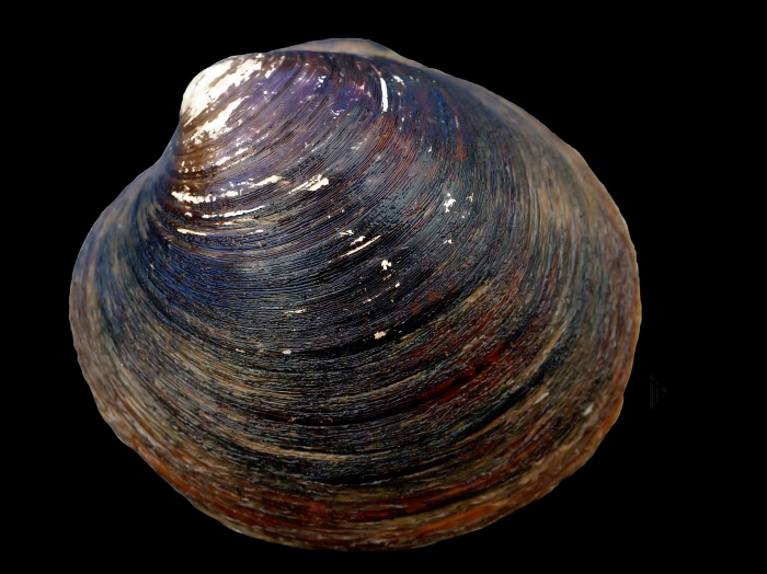
Fulmar rMCZ was visited on the first part of this survey. At just over 2,000km2 it’s half the size of Swallow Sand. Fulmar is being recommended as an MCZ for its subtidal coarse sediments and sands and the Ocean quahog (Artica Islandica)  (see pg 535 for more information). Sixty- five Hamon grab sediment samples were taken and the camera sledge was used to take video and still images at 25 of those stations. Artica Islandica was found in several grab samples (see image below).

Map of Fulmar rMCZ broadscale habitats overlaid with grab stations and multibeam bathymetry

Hagfish from station 261

Seapens at station 229

Crab at station 173
Anemones at station 251


Ocean Quahog (Artica Islandica) from Station 170


It’s important to celebrate the important events at sea and on Wednesday we did just that with balloons, banners and cake for Ruth’s 30th Birthday.

Fionnuala


Tuesday, 15 May 2012


Into the North Sea

Hello and welcome back to the JNCC marine survey blog. We joined the Cefas Endeavour at the Tees North Sea supply base in Middlesborough on Saturday 12th May and set sail early on Sunday morning.

Our Cefas colleagues have been hard at work for the last two weeks gathering multibeam, grab and video data for Markham’s Triangle and Fulmar recommended Marine Conservation Zones (rMCZs). On this part of the survey we will be collecting multibeam and video data in Berwickshire and North Northumberland Coast Special Area of Conservation SAC (BNNC SAC) and multibeam, video and sediment grab data in Swallow Sand and Holderness Offshore rMCZs. The map below shows the rMCZs and Berwickshire and Northumberland Coast SAC. The rMCZs which were surveyed during the first part of the survey are in purple and the rMCZs to be surveyed on this part of the survey are in green.


As the forecast was predicting gale force winds when we left the Tees, we headed straight to BNCC SAC, the closest site to shore, to avoid the worst of the weather. We arrived around 3pm and conducted a CTD before starting detailed mapping of two areas, Holy Island and Farne Islands. Both areas have now been groundtruthed with video and still images and we’re now mapping a third area called Dunstanburg.

For this first blog, we’ll show some of the results from Markham’s Triangle rMCZ (see pg 230 for more information). It has been recommended as an MCZ for its subtidal coarse sediment and subtidal sands and covers an area of around 200km2. The multibeam survey was designed to give approximately 75% coverage of the site. Multibeam data provides both water depths and backscatter data which gives an indication of the substrate type. The strange gap in the multibeam data is due to the Chiswick Field Well which was situated in the middle of some of the survey lines. Sediment grabs were taken at 50 stations to ground-truth the multibeam data. Video and still imagery were also collected with the drop camera from 22 stations.

Fionnuala


Still image from MT39


Still image from MT31


Wednesday, 14 March 2012

Blood Moon Rising and The Planets

We've been lucky enough to see a couple of impressive astronomical sight over the last few nights.

We had a Red Moon rising, this is caused by the same atmospheric process that makes sunsets red. Light from the Moon has to pass through a larger amount of atmosphere when it’s down near the horizon, compared to when it’s overhead. The Earth’s atmosphere scatters the moonlight; blue light is scattered most, while more red light passes through giving the moon a blood like hue.

Red Moon on the Horizon

There are also two very bright stars in the east at the moment, which are in fact Venus and Jupiter. At the moment they are just is 3 degrees apart with Venus the brighter of the two.

Along a similar theme the ship Neptune is also in the area conducting a multibeam survey, we often see her steaming up and down her runlines in the distance.

The Neptune in the distance

The Darwin Code

When we are running video tows we write of commentary of species sighted as we zip past them. We have to be pretty quick to write down everything as it's shouted out thick and fast by the team. To help make sure we do get everything down on paper we use a variety of codes instead of full species names to speed up the process. These are a few examples, some are from official code lists others are simple abbreviations or common names while some are somewhat more informal!

Sabella pavonina
  • Winona [ryder]: Munida rugosa
  • Peacock: Sabella pavonina (Peacock worm)
  • Nem: Nemertesia
  • Bib: Trisopterus luscus
  • LMH: Liocarcinus holsatus
  • API: Astropecten irregularis
  • OP: The Onion People aka Pennatula phosphorea
 
Onion Person
The Onion People came about thanks to Ken who at a glance likened the sea pens to sements of red onion. Hence the Onion people came into existence; populating the sea floor, carrying out clandestine operations to sabotage our equipment before we can assess their true numbers!


Of course the informal names are converted into formal scientific names when entered in our data base and they will be checked when the video goes for processing!

Winona Ryder/Munida rugosa


Friday, 9 March 2012

Who Wants To Live Forever?

The problem with being in the second month of the survey is that there are very few topics that have not already been covered in this blog! However we got lucky today when we found a couple of rather special organism in a grab sample.

The Ocean Quahog (Arctica islandica) may have the longest lifespan of any animal known. While they mature at 10 to 32 years, individuals more than 100 years old are common. The species seems to experience limited senescence (biological ageing) with the oldest specimens found being in the order of 225, 268, and 374 years old!

Arctica islandica - Photo: Hillewaert, Hans

The Ocean Quahog is of great interest to scientists for this very reason. Climatologists can use them as another tool to infer historical climate changes, through changes in their shell growth, much like they do with tree ring and ice cores records. Those looking in to ageing (or even anti-ageing) study the Ocean Quahog's cells, compounds and DNA.

Thursday, 8 March 2012

New habits.... the glorious monkfish


We steamed through the early morning up to Barmade Bank where previously collected acoustic back scatter data indicates that there are outcrops of chalk reef. Here we will be collecting additional video data to help us understand the range and extend of different habitats within in the North Sea area.

Map of Cefas Endeavour's Progress

The night shift have done a grand job collecting drop video transects across the site. Tim managed to capture a photo of the second Monkfish of the survey, other highlights were several squat lobsters and an edible crab.

Lurking Monkfish
Edible Crab
We didn’t hit rock every time, but even the sands had a few interesting specimens to offer, including a fair few sea pens. These are found in the soft coral group of animals, they are plankton feeders and anchor themselves in muddy or sandy ground, and prefer deeper waters were they are less likely to be disturbed by water movements.

Sea Pen


Tuesday, 6 March 2012

It's only rock and roll but I like it...

Hello!

There's been a bit of a break since the last entry; following the departure of Ulric, Hayley and Ana, Endeavour has laid up in Lowestoft for two days for crew change, taking on supplies and preparing for the next phase of the survey.

Over the next two weeks the plan is to collect data to on the range and extent of broad scale habitats in the recommended North Sea MCZ’s, namely Compass Rose, Rock Unique and Farnes East.

With a a fresh crew on board we headed off on a foggy Friday afternoon to our first site, Compass Rose. The weather was kind to us in the first 24 hours however the winds and swell soon picked up.

Leaving Lowestoft through the bridge
Looking back on Lowestoft

There are many general procedures in place to keep the crew safe, everyone has to wear a hard hat and steel toe cap boots or wellies while on desk for instance. There are special cases where additional measures are needed, for instance when we are working with an openings in the stern (back) and side of the ship (these are typically kept closed unless needed for the deployment of the camera sled).

When the side or stern door is open we have to wear a life jackets and personal location beacons. Should the wearer fall over board, the beacons automatically set off an alarm on the bridge, the system also indicates where the ‘man-over-board’ is relative to the ship, this aids search and rescue efforts.
Personal Beacon
Working on the edge!
We have various other tricks and techniques for making the best of bad weather; one simple procedure is to ‘knuckle down’ the cranes used for lifting equipment over the side so that the crane head is much closer to the deck, with less cable out the equipment can’t swing about as much.

Crane 'Knuckled Down'
When the weather is too bad to operate our sampling gear we can sometimes still operate our multibeam, however this too is affected by the weather, as the ship rock and rolls it increases the errors in our data.

Sunday night through Monday we worked through Force 8 gales and rough seas, head way was slow against the winds and data quality was poor. Typically when collecting multibeam data we travel up and down the area of interest like you would if you were mowing a lawn, however we found we were able to get adequate data when running in one direction with the winds, so for each zig-zap across the site we were only collecting half the usual amount of data; we'll something is better that nothing in these situations!
Force 8 Gales
We have finished our last video sled run tonight, so with only a few lines of multibeam to collect at the Compass Rose site, we'll soon be heading north to an interesting 'Chalk Reef' on our way to Rock Unique, but more on that tomorrow...